Why You Should Bring a Physical Map on Your Next Road Trip

Developing Real-World Navigation Skills
No More Dead Zones or Battery Anxiety
Turning Travel into a Collaborative Game
Discovering Hidden Gems Off the Main Route
Reducing Digital Fatigue for Kids
A smartphone sits in a car cup holder, its screen displaying a spinning blue dot that refuses to move because the signal dropped three miles back. The battery icon is flashing red, the GPS is stuck in a loop between a dirt road and a dead end, and the kids in the backseat are starting to realize that "five more minutes" was a lie. This is the reality of digital dependency during a family road trip. While we rely heavily on Google Maps and Waze, bringing a physical map—specifically a high-quality paper atlas—is a tactical decision that saves time, reduces parental stress, and prevents total logistical collapses. This post outlines the practical, non-romanticized reasons why a paper map is a mandatory piece of gear for your next long-haul drive.
The Reliability of Analog Technology
Digital navigation is a marvel of engineering, but it is incredibly fragile. It relies on a complex stack of technologies: GPS satellites, cellular towers, and a functioning battery. When one of these components fails, your navigation fails. In many scenic or remote areas, such as the Blue Ridge Mountains in Virginia or the high deserts of Utah, cellular service is not a guarantee; it is a luxury. A paper map does not require a 5G connection, and it certainly doesn't care if you are in a dead zone.
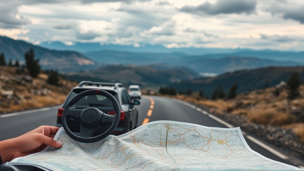
A physical map provides a constant, unwavering source of truth. While a GPS might tell you to "turn left" into a seasonal logging road that is currently underwater, a detailed Rand McNally Road Atlas shows you the actual layout of the terrain. It provides context that a screen cannot. You can see the mountain ranges, the national forests, and the secondary highways that might serve as much better alternatives to a congested interstate. Having this visual context allows you to plan a detour before you are actually stuck in one.
The Battery Factor
We have all been there: you are using your phone for navigation, music, and a quick check of the weather, and suddenly the screen goes black. Even if you pack a portable power bank, there is a limit to how much energy you can cycle through a device during a ten-hour drive. A dead phone in a car full of hungry, tired children is a recipe for a high-decibel meltdown. A paper map requires zero percent of your phone's battery life, leaving that precious power available for the things that actually keep the kids occupied, like downloading a movie or playing a game.
Spatial Awareness and Long-Term Planning
Digital maps are designed for the "now." They are excellent at telling you where to turn in 200 feet, but they are terrible at helping you understand where you are in relation to your destination. When you look at a screen, you are looking at a narrow straw-view of the world. When you look at a map, you see the whole picture. This is crucial for family travel, where "the journey" often involves multiple stops for food, fuel, or bathroom breaks.
Using a physical map develops a sense of spatial awareness that digital pings destroy. If you see a large forest or a mountain range on the map, you understand why the highway is curving the way it is. You can anticipate the landscape. This is particularly helpful when you are trying to coordinate a multi-stop trip, such as driving from a hotel in Asheville to a specific trailhead in the Great Smoky Mountains. You can visualize the entire route and identify potential waypoints, like a specific town with a highly-rated diner or a state park with clean facilities, long before you reach them.
Engaging the Passengers
The "Are we there yet?" phenomenon is a byproduct of a lack of engagement. When kids are staring at the back of a headrest or a screen, they have no concept of progress. A map offers a tactile way to involve older children or teenagers in the logistics of the trip. You can hand the map to a teenager and ask them to track your progress or identify the next major city. This turns a passive, frustrating experience into a low-stakes navigation exercise. It gives them a job, and in the world of family travel, a child with a job is a child who is less likely to complain.
The Safety Net for Unforeseen Detours
Road construction, accidents, and weather events can change a route in an instant. While Waze is excellent at rerouting you around a crash on I-95, it often does so by sending you through residential neighborhoods or narrow streets that might not be suitable for a large SUV or a minivan loaded with gear. A physical atlas allows you to see the "big picture" of the detour. You can see if the suggested alternative route actually leads to a major highway or if it’s a winding backroad that will add two hours to your trip.
- Check for State Parks and Rest Areas: Digital maps often skip the smaller, state-run rest areas that are frequently cleaner and quieter than major interstate service plazas.
- Identify Fuel Gaps: In the Western United States, gas stations can be 50 or more miles apart. A paper map allows you to see these gaps clearly and plan your fuel stops with much higher precision.
- Verify Road Types: A map will explicitly label roads as "unpaved," "seasonal," or "scenic," which is vital information if you are driving a vehicle with low ground clearance.
Practical Tips for Using a Physical Map
To make a paper map actually useful in a moving vehicle, you need to treat it like any other piece of tactical gear. Do not just shove it in the glove box and hope for the best. Follow these steps to ensure it becomes a functional tool rather than a piece of clutter.
- Buy a Large-Format Atlas: Do not buy a small, pocket-sized map. You need a full-sized road atlas (like the Rand McNally Motor Atlas) that allows you to see multiple counties or states at once. The more detail, the better.
- Invest in a Map Case or Folder: Maps get crumpled and torn in a car environment. A dedicated map folder or even a large, clear plastic sleeve keeps the pages crisp and easy to manipulate.
- Assign a "Navigator": If you have an older child or a co-pilot, give them the map. Let them be the one to find the next exit or the next town. It builds a skill and keeps them focused on the environment.
- Cross-Reference with Digital: Use the map to verify what the GPS is telling you. If the GPS says "Turn Right" and the map shows that the road is a dead end, trust the map.
A physical map is not a replacement for your smartphone; it is a redundant system. In aviation and maritime navigation, redundancy is the difference between a successful mission and a disaster. In family travel, it is the difference between a minor inconvenience and a full-blown logistical crisis. Pack the atlas, keep it accessible, and use it to gain a better understanding of the world you are driving through.